Friday, March 29, 2019

(98).Introduction to ocean.


Vocabulary

aphotic zone


biomass


intertidal zone


neritic zone


oceanic zone


photic zone


salinity


water column


Introduction

As terrestrial creatures, humans think of the importance of the planet’s land surfaces. But Earth is mostly a water planet. From space, the dominance of water is obvious (Figure below). Most of Earth’s water is in the oceans.

[Figure 1]

About 71% of the Earth’s surface is covered with water, mostly by the oceans.

Because all of Earth’s oceans are somehow connected, should this chapter be titled “Earth’s Ocean” or “Earth’s Oceans?” Try to decide by the end of the chapter.

An animation will help you see Earth's one, three, four, or five oceans: http://en.wikipedia.org/wiki/File:World_ocean_map.gif.

Significance of the Oceans

Earth would not be the same planet without its oceans.

Moderates Climate

The oceans, along with the atmosphere, keep temperatures fairly constant worldwide. While some places on Earth get as cold as -70oC and others as hot as 55oC, the range is only 125oC. On Mercury temperatures go from -180oC to 430oC, a range of 610oC.

The oceans, along with the atmosphere, distribute heat around the planet. The oceans absorb heat near the equator and then move that solar energy to more polar regions. The oceans also moderate climate within a region. At the same latitude, the temperature range is smaller in lands nearer the oceans than away from the oceans. Summer temperatures are not as hot, and winter temperatures are not as cold, because water takes a long time to heat up or cool down.
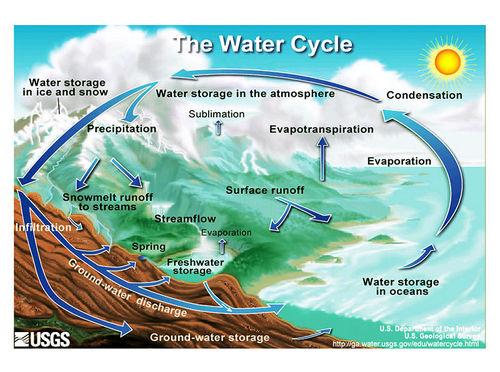
Water Cycle

The oceans are an essential part of Earth’s water cycle. Since they cover so much of the planet, most evaporation comes from the ocean and most precipitation falls on the oceans.

Biologically Rich

The oceans are home to an enormous amount of life. That is, they have tremendous biodiversity (Figure below). Tiny ocean plants create the base of a food web that supports all sorts of life forms. Marine life makes up the majority of all biomass on Earth. (Biomass is the total mass of living organisms in a given area.) These organisms supply us with food and even the oxygen created by marine plants.

[Figure 2]

A swimming polar bear is a tiny part of the immense biodiversity of the oceans.

Continental Margin

Recall from the Plate Tectonics chapter that the ocean floor is not flat: mid-ocean ridges, deep sea trenches, and other features all rise sharply above or plunge deeply below the abyssal plains. In fact, Earth’s tallest mountain is Mauna Kea volcano, which rises 10,203 m (33,476 ft.)meters) from the Pacific Ocean floor to become one of the volcanic mountains of Hawaii. The deepest canyon is also on the ocean floor, the Challenger Deep in the Marianas Trench, 10,916 m (35,814 ft).

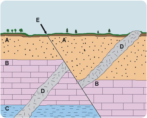
The continental margin is the transition from the land to the deep sea or, geologically speaking, from continental crust to oceanic crust. More than one-quarter of the ocean basin is continental margin. (Figure below).

[Figure 3]

The continental margin is divided into the continental shelf, continental slope, and continental rise, based on the steepness of the slope.

Composition of Ocean Water

Remember from the Mineral's chapter that H2O is a polar molecule so it can dissolve many substances (Figurebelow). Salts, sugars, acids, bases, and organic molecules can all dissolve in water.

[Figure 4]

Ocean water is composed of many substances, many of them salts such as sodium, magnesium, and calcium chloride.

Where does the salt in seawater come from? As water moves through rock and soil on land it picks up ions. This is the flip side of weathering. Salts comprise about 3.5% of the mass of ocean water, but the salt content or salinity is different in different locations.

What would the salinity be like in an estuary? Where seawater mixes with fresh water, salinity is lower than average.

What would the salinity be like where there is lots of evaporation? Where there is lots of evaporation but little circulation of water, salinity can be much higher. The Dead Sea has 30% salinity—nearly nine times the average salinity of ocean water (Figure below). Why do you think this water body is called the Dead Sea?

[Figure 5]

The Dead Sea has such high salinity that people can easily float in it.

Interactive ocean maps can show salinity, temperature, nutrients, and other characteristics: http://earthguide.ucsd.edu/earthguide/diagrams/levitus/index.html.

With so many dissolved substances mixed in seawater, what is the density (mass per volume) of seawater relative to fresh water?

Water density increases as:

salinity increases


temperature decreases


pressure increases


Differences in water density are responsible for deep ocean currents, as will be discussed in the Ocean Movements lesson.

The Water Column

In 1960, two men in a specially designed submarine called the Trieste descended into a submarine trench called the Challenger Deep (10,910 meters) (Figurebelow).

[Figure 6]

The Trieste made a record dive to the Challenger Deep in 1960.

The average depth of the ocean is 3,790 m, a lot more shallow than the deep trenches but still an incredible depth for sea creatures to live in. What makes it so hard to live at the bottom of the ocean? The three major factors that make the deep ocean hard to inhabit are the absence of light, low temperature, and extremely high pressure.

Vertical Divisions

To better understand regions of the ocean, scientists define the water column by depth. They divide the entire ocean into two zones vertically, based on light level. Large lakes are divided into similar regions.

Sunlight only penetrates the sea surface to a depth of about 200 m, creating the photic zone (photic means light). Organisms that photosynthesize depend on sunlight for food and so are restricted to the photic zone. Since tiny photosynthetic organisms, known as phytoplankton, supply nearly all of the energy and nutrients to the rest of the marine food web, most other marine organisms live in or at least visit the photic zone.


In the aphotic zone there is not enough light for photosynthesis. The aphotic zone makes up the majority of the ocean, but has a relatively small amount of its life, both in diversity of type and in numbers. The aphotic zone is subdivided based on depth (Figure below).


[Figure 7]

Oceanographers divide the ocean into zones both vertically and horizontally.

Horizontal Divisions

The seabed is divided into the zones described above, but ocean itself is also divided horizontally by distance from the shore.

Nearest to the shore lies the intertidal(littoral) zone, the region between the high and low tidal marks. This hallmark of the intertidal is change: water is in constant motions in waves, tides, and currents. The land is sometimes under water and sometimes is exposed.


The neritic zone is from low tide mark and slopes gradually downward to the edge of the seaward side of the continental shelf. Some sunlight penetrates to the seabed here.


The oceanic zone is the entire rest of the ocean from the bottom edge of the neritic zone, where sunlight does not reach the bottom. The sea bed and water column are subdivided further, as seen in the above).


Lesson Summary

The oceans help to moderate Earth's temperatures.


The main elements in seawater are chlorine, sodium, magnesium, sulfate, and calcium.


The average salinity of the oceans is about 3.5%.


In seawater, if evaporation is high, salinity is high. If fresh water mixes in, salinity is low.


In the photic zone there is enough available light for photosynthesis.


The vast majority of the ocean lies in the aphotic zone, where there is not enough light for photosynthesis.


The ocean floor averages about 3,790 m but ocean trenches are as deep as 10,910 m.


The neritic zones are nearshore areas, including the intertidal zone. The oceanic zones are offshore regions of the ocean.


(97).Earth's oceans.


Phytoplankton bloom in spring when sunlight hits the water. The green color is from chlorophyll, the pigment needed for photosynthesis. The blue color is from the reflective plating around coccolithophores, a type of phytoplankton. The Chatham Rise is an underwater plateau that causes deep water to rise, bringing up nutrients. The feature is located where cold Antarctic currents meet warmer, subtropical water. The mixing of water and the nutrients foster large phytoplankton blooms.

Phytoplankton are the base of the marine food web and so they are food to nearly all other marine organisms. By using carbon dioxide for photosynthesis, phytoplankton help to reduce the buildup of greenhouse gases in the atmosphere.

Courtesy of Norman Kuring/NASA's Earth Observatory. earthobservatory.nasa.gov/IOTD/view.php?id=42099. Public Domain.


(96).Groundwater


Vocabulary

aquifer


capillary action


impermeable


permeability


porosity


spring


subsidence


water table


well


Introduction

Although this may seem surprising, water beneath the ground is commonplace. Usually groundwater travels slowly and silently beneath the surface, but in some locations it bubbles to the surface at springs. The products of erosion and deposition by groundwater were described in the Erosion and Deposition chapter.

Groundwater

Groundwater is the largest reservoir of liquid fresh water on Earth and is found in aquifers, porous rock and sediment with water in between. Water is attracted to the soil particles and capillary action, which describes how water moves through a porous media, moves water from wet soil to dry areas.

Aquifers are found at different depths. Some are just below the surface and some are found much deeper below the land surface. A region may have more than one aquifer beneath it and even most deserts are above aquifers. The source region for an aquifer beneath a desert is likely to be far from where the aquifer is located; for example, it may be in a mountain area.

The amount of water that is available to enter groundwater in a region is influenced by the local climate, the slope of the land, the type of rock found at the surface, the vegetation cover, land use in the area, and water retention, which is the amount of water that remains in the ground. More water goes into the ground where there is a lot of rain, flat land, porous rock, exposed soil, and where water is not already filling the soil and rock.

The residence time of water in a groundwater aquifer can be from minutes to thousands of years. Groundwater is often called “fossil water” because it has remained in the ground for so long, often since the end of the ice ages.

Aquifers

Features of an Aquifer

To be a good aquifer, the rock in the aquifer must have good:

porosity: small spaces between grains


permeability: connections between pores


This animation shows porosity and permeability. The water droplets are found in the pores between the sediment grains, which is porosity. When the water can travel between ores, that’s permeability. http://www.nature.nps.gov/GEOLOGY/usgsnps/animate/POROS_3.MPG

To reach an aquifer, surface water infiltrates downward into the ground through tiny spaces or pores in the rock. The water travels down through the permeable rock until it reaches a layer that does not have pores; this rock is impermeable (Figure below). This impermeable rock layer forms the base of the aquifer. The upper surface where the groundwater reaches is the water table.

[Figure 1]

Groundwater is found beneath the solid surface. Notice that the water table roughly mirrors the slope of the land’s surface. A well penetrates the water table.

The Water Table

For a groundwater aquifer to contain the same amount of water, the amount of recharge must equal the amount of discharge. What are the likely sources of recharge? What are the likely sources of discharge?

In wet regions, streams are fed by groundwater; the surface of the stream is the top of the water table (Figure below). In dry regions, water seeps down from the stream into the aquifer. These streams are often dry much of the year. Water leaves a groundwater reservoir in streams or springs. People take water from aquifers, too.

What happens to the water table when there is a lot of rainfall? What happens when there is a drought? Although groundwater levels do not rise and fall as rapidly as at the surface, over time the water table will rise during wet periods and fall during droughts.

[Figure 2]

The top of the stream is the top of the water table. The stream feeds the aquifer.

One of the most interesting, but extremely atypical types of aquifers is found in Florida. Although aquifers are very rarely underground rivers, in Florida water has dissolved the limestone so that streams travel underground and above ground (Figure below).

[Figure 3]

In Florida, groundwater is sometimes not underground.

Groundwater Use

Groundwater is an extremely important water source for people. Groundwater is a renewable resource and its use is sustainable when the water pumped from the aquifer is replenished. It is important for anyone who intends to dig a well to know how deep beneath the surface the water table is. Because groundwater involves interaction between the Earth and the water, the study of groundwater is called hydrogeology.

Some aquifers are overused; people pump out more water than is replaced. As the water is pumped out, the water table slowly falls, requiring wells to be dug deeper, which takes more money and energy. Wells may go completely dry if they are not deep enough to reach into the lowered water table.

The Ogallala Aquifer supplies about one-third of the irrigation water in the United States (Figure below). The aquifer is found from 30 to 100 meters deep over about 440,000 square kilometers! The water in the aquifer is mostly from the last ice age.

The Ogallala Aquifer is widely used by people for municipal and agricultural needs.

[Figure 4]

The Ogallala Aquifer is found beneath eight states and is heavily used.

About eight times more water is taken from the Ogallala Aquifer each year than is replenished. Much of the water is used for irrigation (Figure below).

[Figure 5]

Farms in Kansas use central pivot irrigation, which is more efficient since water falls directly on the crops instead of being shot in the air. These fields are between 800 and 1600 meters (0.5 and 1 mile) in diameter.

Lowering the water table may cause the ground surface to sink. Subsidence may occur beneath houses and other structures (Figure below).

[Figure 6]

The San Joaquin Valley of California is one of the world’s major agricultural areas. So much groundwater has been pumped that the land has subsided many tens of feet.

When coastal aquifers are overused, salt water from the ocean may enter the aquifer, contaminating the aquifer and making it less useful for drinking and irrigation. Salt water incursion is a problem in developed coastal regions, such as on Hawaii.

Springs

Groundwater meets the surface in a stream, as shown above, or a spring(Figure below). A spring may be constant, or may only flow at certain times of year.

[Figure 7]

(a) Big Spring in Missouri lets out 12,000 liters of water per second. (b) Other springs are just tiny outlets like this one.

Towns in many locations depend on water from springs. Springs can be an extremely important source of water in locations where surface water is scarce (Figure below).

[Figure 8]

In the dry Arizona desert, Oak Creek and many other streams are spring fed.

Wells

well is created by digging or drilling to reach groundwater. When the water table is close to the surface, wells are a convenient method for extracting water. When the water table is far below the surface, specialized equipment must be used to dig a well. Most wells use motorized pumps to bring water to the surface, but some still require people to use a bucket to draw water up (Figurebelow).

[Figure 9]

An old-fashioned well that uses a bucket drawn up by hand.

Lesson Summary

Groundwater is the largest reservoir of fresh water.


The water table is the top of an aquifer below which is water and above is rock or soil mixed with air.


Aquifers are underground areas of sediment or rock that hold groundwater.


An aquifer needs good porosity and permeability.


Where groundwater intersects the ground surface, a spring can form.


People dig or drill wells to access groundwater.


FlexBook® Platform

(95).Surface water


Vocabulary

brackish


confluence


continental divide


divide


estuary


flood


lake


levee


limnology


marsh


mouth


pond


pool


stream


swamp


tributary


wetland


Introduction

Fresh water in streams, ponds, and lakes is an extremely important part of the water cycle if only because of its importance to living creatures. Along with wetlands, these fresh water regions contain a tremendous variety of organisms.

Streams and Rivers

Streams are bodies of water that have a current; they are in constant motion. Geologists recognize many categories of streams depending on their size, depth, speed, and location. Creeks, brooks, tributaries, bayous, and rivers might all be lumped together as streams. In streams, water always flows downhill, but the form that downhill movement takes varies with rock type, topography, and many other factors. Stream erosion and deposition are extremely important creators and destroyers of landforms and were described in the Erosion and Deposition chapter.

Parts of a Stream

A stream originates at its source. A source is likely to be in the high mountains where snows collect in winter and melt in summer, or a source might be a spring. A stream may have more than one source.

Two streams come together at a confluence. The smaller of the two streams is a tributary of the larger stream (Figure below).

[Figure 1]

The largest band of blue, from left to right across the image, is the Rio Negro in Brazil. The other streams are tributaries of that river. Their confluence is near the bottom right.

A stream may create a pool where water slows and becomes deeper (Figurebelow).

[Figure 2]

A stream pool in Maui.

The point at which a stream comes into a large body of water, like an ocean or a lake is called the mouth. Where the stream meets the ocean or lake is an estuary (Figure below).

[Figure 3]

The Parana River drains South America and enters the Atlantic Ocean.

The mix of fresh and salt water where a river runs into the ocean creates a diversity of environments where many different types of organisms create unique ecosystems (Figure below).

[Figure 4]

The Klamath River enters the Pacific at Redwood National Park.

Rivers

Rivers are the largest types of stream, moving large amounts of water from higher to lower elevations (Figurebelow). The Amazon River, the world’s river with the greatest flow, has a flow rate of nearly 220,000 cubic meters per second!

[Figure 5]

The famous Horseshoe Falls at Niagara Falls drops over 1,800 cubic meters of water per second, down a cliff nearly 50 meters (170 feet) in height. The falls are fed by Lake Erie and the Niagara River.

People have used rivers since the beginning of civilization as a source of water, food, transportation, defense, power, recreation, and waste disposal.

Divides

divide is a topographically high area that separates a landscape into different water basins (Figure below). Rain that falls on the north side of a ridge flows into the northern drainage basin and rain that falls on the south side flows into the southern drainage basin. On a much grander scale, entire continents have divides, known as continental divides.

[Figure 6]

(a) The divides of North America. In the Rocky Mountains in Colorado, where does a raindrop falling on the western slope end up? How about on the eastern slope? (b) At Triple Divide Peak in Montana water may flow to the Pacific, the Atlantic, or Hudson Bay depending on where it falls. Can you locate where in the map of North America (above) this peak sits?

Ponds and Lakes

Ponds and lakes are bordered by hills or low rises, so that the water is blocked from flowing directly downhill. Ponds are small bodies of fresh water that usually have no outlet (Figure below); ponds are often are fed by underground springs.

[Figure 7]

Ponds are small, enclosed bodies of water.

Lakes are larger bodies of water. Lakes are usually fresh water, although the Great Salt Lake in Utah is just one exception. Water usually drains out of a lake through a river or a stream and all lakes lose water to evaporation.

Large lakes have tidal systems and currents, and can even affect weather patterns. The Great Lakes in the United States contain 22% of the world’s fresh surface water (Figure below). The largest them, Lake Superior, has a tide that rises and falls several centimeters each day. The Great Lakes are large enough to alter the weather system in Northeastern United States by the “lake effect,” which is an increase in snow downwind of the relatively warm lakes. The Great Lakes are home to countless species of fish and wildlife.

Lakes form in a variety of different ways: in depressions carved by glaciers, in calderas (Figure below), and along tectonic faults, to name a few. Subglacial lakes are even found below a frozen ice cap.

[Figure 8]

(a) Crater Lake in Oregon is in a volcanic caldera. Lakes can also form in volcanic craters and impact craters. (b) The Great Lakes fill depressions eroded as glaciers scraped rock out from the landscape. (c) Lake Baikail, ice coated in winter in this image, formed as water filled up a tectonic faults.

As a result of geologic history and the arrangement of land masses, most lakes are in the Northern Hemisphere. In fact, more than 60% of all the world’s lakes are in Canada — most of these lakes were formed by the glaciers that covered most of Canada in the last Ice Age (Figure below).

[Figure 9]

Lakes near Yellowknife were carved by glaciers during the last Ice Age.

Limnology is the study of bodies of fresh water and the organisms that live there. The ecosystem of a lake is divided into three distinct sections (Figure below):

1. The surface (littoral) zone is the sloped area closest to the edge of the water.

2. The open-water zone (also the photic or limnetic zone) has abundant sunlight.

3. The deep-water zone (also the aphotic or profundal zone) has little or no sunlight. There are several life zones found within a lake:

In the littoral zone, sunlight promotes plant growth, which provides food and shelter to animals such as snails, insects, and fish.


In the open-water zone, other plants and fish, such as bass and trout, live.


The deep-water zone does not have photosynthesis since there is no sunlight. Most deep-water organisms are scavengers, such as crabs and catfish that feed on dead organisms that fall to the bottom of the lake. Fungi and bacteria aid in the decomposition in the deep zone.


Though different creatures live in the oceans, ocean waters also have these same divisions based on sunlight with similar types of creatures that live in each of the zones.

[Figure 10]

The three primary zones of a lake are the littoral, open-water, and deep-water zones.

Lakes are not permanent features of a landscape. Some come and go with the seasons, as water levels rise and fall. Over a longer time, lakes disappear when they fill with sediments, if the springs or streams that fill them diminish, or if their outlets grow because of erosion. When the climate of an area changes, lakes can either expand or shrink (Figure below). Lakes may disappear if precipitation significantly diminishes.

[Figure 11]

The Badwater Basin in Death Valley contains water in wet years. The lake basin is a remnant from when the region was much wetter just after the Ice Ages.

Wetlands

Wetlands are lands that are wet for significant periods of time. They are common where water and land meet. Wetlands can be large flat areas or relatively small and steep areas.

Wetlands are rich and unique ecosystems with many species that rely on both the land and the water for survival. Only specialized plants are able to grow in these conditions. Wetlands tend have a great deal of biological diversity. Wetland ecosystems can also be fragile systems that are sensitive to the amounts and quality of water present within them.

Types of Wetlands

Marshes are shallow wetlands around lakes, streams, or the ocean where grasses and reeds are common, but trees are not (Figure below). Frogs, turtles, muskrats, and many varieties of birds are at home in marshes.

[Figure 12]

A marsh is a treeless wetland.

swamp is a wetland with lush trees and vines found in a low-lying area beside slow-moving rivers (Figure below). Like marshes, they are frequently or always inundated with water. Since the water in a swamp moves slowly, oxygen in the water is often scarce. Swamp plants and animals must be adapted for these low-oxygen conditions. Like marshes, swamps can be fresh water, salt water, or a mixture of both.

[Figure 13]

A swamp is characterized by trees in still water.

In an estuary, salt water from the sea mixes with fresh water from a stream or river (Figure below). These semi-enclosed areas are home to plants and animals that can tolerate the sharp changes in salt content that the constant motion and mixing of waters creates. Estuaries contain brackish water, water that has more salt than fresh water but less than sea water. Because of the rapid changes in salt content, estuaries have many different habitats for plants and animals and extremely high biodiversity.

[Figure 14]

Chesapeake Bay, surrounded by Maryland and Virginia, is the largest estuary in the United States.

Ecological Role of Wetlands

As mentioned above, wetlands are home to many different species of organisms. Although they make up only 5% of the area of the United States, wetlands contain more than 30% of the plant types. Many endangered species live in wetlands, so wetlands are protected from human use.

Wetlands also play a key biological role by removing pollutants from water. For example, they can trap and use fertilizer that has washed off a farmer’s field, and therefore they prevent that fertilizer from contaminating another body of water. Since wetlands naturally purify water, preserving wetlands also helps to maintain clean supplies of water.

Floods

Floods are a natural part of the water cycle, but they can be terrifying forces of destruction. Put most simply, a flood is an overflow of water in one place. Floods can occur for a variety of reasons, and their effects can be minimized in several different ways. Perhaps unsurprisingly, floods tend to affect low-lying areas most severel

Causes of Floods

Floods usually occur when precipitation falls more quickly than that water can be absorbed into the ground or carried away by rivers or streams. Waters may build up gradually over a period of weeks, when a long period of rainfall or snowmelt fills the ground with water and raises stream levels.

Extremely heavy rains across the Midwestern U.S. in April 2011 led to flooding of the rivers in the Mississippi River basin in May 2011 (Figures belowand below).

[Figure 15]

This map shows the accumulated rainfall across the U.S. in the days from April 22 to April 29, 2011.

[Figure 16]

Record flow in the Ohio and Mississippi Rivers has to go somewhere. Normal spring river levels are shown in 2010. The flooded region in the image from May 3, 2011 is the New Madrid Floodway, where overflow water is meant to go. 2011 is the first time since 1927 that this floodway was used.

Flash floods are sudden and unexpected, taking place when very intense rains fall over a very brief period (Figure below). A flash flood may do its damage miles from where the rain actually falls if the water travels far down a dry streambed so that the flash flood occurs far from the location of the original storm.

[Figure 17]

A 2004 flash flood in England devastated two villages when 3-1/2 inches of rain fell in 60 minutes. Pictured here is some of the damage from the flash flood.

Heavily vegetated lands are less likely to experience flooding. Plants slow down water as it runs over the land, giving it time to enter the ground. Even if the ground is too wet to absorb more water, plants still slow the water’s passage and increase the time between rainfall and the water’s arrival in a stream; this could keep all the water falling over a region to hit the stream at once. Wetlands act as a buffer between land and high water levels and play a key role in minimizing the impacts of floods. Flooding is often more severe in areas that have been recently logged.

When a dam breaks along a reservoir, flooding can be catastrophic. High water levels have also caused small dams to break, wreaking havoc downstream.

People try to protect areas that might flood with dams, and dams are usually very effective. People may also line a river bank with levees, high walls that keep the stream within its banks during floods. A levee in one location may just force the high water up or downstream and cause flooding there. The New Madrid Overflow in the Figure above was created with the recognition that the Mississippi River sometimes simply cannot be contained by levees and must be allowed to flood.

Effects of Floods

Not all the consequences of flooding are negative. Rivers deposit new nutrient-rich sediments when they flood and so floodplains have traditionally been good for farming. Flooding as a source of nutrients was important to Egyptians along the Nile River until the Aswan Dam was built in the 1960s. Although the dam protects crops and settlements from the annual floods, farmers must now use fertilizers to feed their crops.

Floods are also responsible for moving large amounts of sediments about within streams. These sediments provide habitats for animals, and the periodic movement of sediment is crucial to the lives of several types of organisms. Plants and fish along the Colorado River, for example, depend on seasonal flooding to rearrange sand bars.

Lesson Summary

Streams return water to the oceans.


Stream headwaters are at higher elevations where snow melts or where there are springs.


Tributaries join together as a river flows to its mouth at lower elevations.


A river may eventually form a delta with an estuary where it meets the ocean.


Water temporarily resides in ponds and lakes, which are mostly fresh water.


Flooding is part of the natural cycle of rivers, enriching floodplains with nutrients, but flooding may destroy crops and settlements.


(94).Water on earth


Vocabulary

condensation


evaporation


fresh water


groundwater


hydrologic (water) cycle


precipitation


reservoir


residence time


sublimation


transpiration


water vapor


Introduction

Water is simply two atoms of hydrogen and one atom of oxygen bonded together. Despite its simplicity, water has remarkable properties. Water expands when it freezes, has high surface tension (because of the polar nature of the molecules, they tend to stick together), and others. Without water, life might not be able to exist on Earth and it certainly would not have the tremendous complexity and diversity that we see.

Distribution of Earth’s Water

Earth’s oceans contain 97% of the planet’s water, so just 3% is fresh water, water with low concentrations of salts (Figure below). Most fresh water is trapped as ice in the vast glaciers and ice sheets of Greenland. A storage location for water such as an ocean, glacier, pond, or even the atmosphere is known as a reservoir. A water molecule may pass through a reservoir very quickly or may remain for much longer. The amount of time a molecule stays in a reservoir is known as its residence time.

How is the 3% of fresh water divided into different reservoirs? How much of that water is useful for living creatures? How much for people?

[Figure 1]

The distribution of Earth’s water.

The Hydrologic Cycle

Because of the unique properties of water, water molecules can cycle through almost anywhere on Earth. The water molecule found in your glass of water today could have erupted from a volcano early in Earth history. In the intervening billions of years, the molecule probably spent time in a glacier or far below the ground. The molecule surely was high up in the atmosphere and maybe deep in the belly of a dinosaur. Where will that water molecule go next?

Three States of Water

Water is the only substance on Earth that is present in all three states of matter – as a solid, liquid or gas. (And Earth is the only planet where water is present in all three states.) Because of the ranges in temperature in specific locations around the planet, all three phases may be present in a single location or in a region. The three phases are solid (ice or snow), liquid (water), and gas (water vapor). See ice, water, and clouds (Figure below).

[Figure 2]

(a) Ice floating in the sea. Can you find all three phases of water in this image? (b) Liquid water. (c) Water vapor is invisible, but clouds that form when water vapor condenses are not.

The Water Cycle

Because Earth’s water is present in all three states, it can get into a variety of environments around the planet. The movement of water around Earth’s surface is the hydrologic (water) cycle(Figure below).

[Figure 3]

Because it is a cycle, the water cycle has no beginning and no end.

The Sun, many millions of kilometers away, provides the energy that drives the water cycle. Our nearest star directly impacts the water cycle by supplying the energy needed for evaporation.

Most of Earth’s water is stored in the oceans where it can remain for hundreds or thousands of years. The oceans are discussed in detail in the chapter Earth's Oceans.

Water changes from a liquid to a gas by evaporation to become water vapor. The Sun’s energy can evaporate water from the ocean surface or from lakes, streams, or puddles on land. Only the water molecules evaporate; the salts remain in the ocean or a fresh water reservoir.

The water vapor remains in the atmosphere until it undergoes condensation to become tiny droplets of liquid. The droplets gather in clouds, which are blown about the globe by wind. As the water droplets in the clouds collide and grow, they fall from the sky as precipitation. Precipitation can be rain, sleet, hail, or snow. Sometimes precipitation falls back into the ocean and sometimes it falls onto the land surface.

For a little fun, watch this video. This water cycle song focuses on the role of the sun in moving H2O from one reservoir to another. The movement of all sorts of matter between reservoirs depends on Earth’s internal or external sources of energy (7c):

When water falls from the sky as rain it may enter streams and rivers that flow downward to oceans and lakes. Water that falls as snow may sit on a mountain for several months. Snow may become part of the ice in a glacier, where it may remain for hundreds or thousands of years. Snow and ice may go directly back into the air by sublimation, the process in which a solid changes directly into a gas without first becoming a liquid. Although you probably have not seen water vapor sublimating from a glacier, you may have seen dry ice sublimate in air.

Snow and ice slowly melt over time to become liquid water, which provides a steady flow of fresh water to streams, rivers, and lakes below. A water droplet falling as rain could also become part of a stream or a lake. At the surface, the water may eventually evaporate and reenter the atmosphere.

A significant amount of water infiltrates into the ground. Soil moisture is an important reservoir for water (Figurebelow). Water trapped in soil is important for plants to grow.

[Figure 4]

The moisture content of soil in the United States varies greatly.

Water may seep through dirt and rock below the soil through pores infiltrating the ground to go into Earth’s groundwater system. Groundwater enters aquifers that may store fresh water for centuries. Alternatively, the water may come to the surface through springs or find its way back to the oceans.

Plants and animals depend on water to live and they also play a role in the water cycle. Plants take up water from the soil and release large amounts of water vapor into the air through their leaves (Figure below), a process known as transpiration.

[Figure 5]

Clouds form above the Amazon Rainforest even in the dry season because of moisture from plant transpiration.

People also depend on water as a natural resource. Not content to get water directly from streams or ponds, humans create canals, aqueducts, dams, and wells to collect water and direct it to where they want it (Figure below).

[Figure 6]

The Pont du Gard aqueduct in France was constructed during the Roman Empire.

Water UseUseUnited StatesGlobalAgriculture34%70%Domestic (drinking, bathing)12%10%Industry5%20%Power plant cooling49%small

Table abovedisplays water use in the United States and globally.

It is important to note that water molecules cycle around. If climate cools and glaciers and ice caps grow, there is less water for the oceans and sea level will fall. The reverse can also happen.

KQED: Tracking Raindrops

How the water cycle works and how rising global temperatures will affect the water cycle, especially in California, are the topics of this Quest video. Learn more at:

Lesson Summary

Although Earth's surface is mostly water covered, only 3% is fresh water.


Water on Earth is found in all three phases: solid, liquid, and gas.


Water travels between phases and reservoirs as part of the hydrologic (water) cycle.


The major processes of the water cycle include evaporation, transpiration, condensation, precipitation, and return to the oceans via runoff and groundwater supplies.


(93).Earth's fresh water


This unusual view of the world is oriented on the Arctic around summer solstice, June 2010, when the region is bathed in daylight 24 hours a day. The Arctic Circle is marked by a faint circle in the image.

Water appears in several forms in this image: as solid ice, liquid water, and atmospheric gases. Greenland has the highest albedo (that is, it appears the brightest) because it is covered with an ice cap. Sea ice, found west and north of Greenland, appears as a pale gray-blue. Clouds are water vapor and appear throughout the area. Through the clouds, oceans, and possibly even lakes – liquid water – is visible.

Courtesy of Jeff Schmaltz/NASA's Earth Observatory. earthobservatory.nasa.gov/IOTD/view.php?id=44524. Public Domain.

m

Thursday, March 28, 2019

(86).Relative age of rockks.


Vocabulary

biozone


cross-cutting relationships


geologic time scale


key bed


lateral continuity


microfossil


original horizontality


relative age


superposition


unconformity


uniformitarianism


Introduction

Something that we hope you have learned from these lessons and from your own life experience is that the laws of nature never change. They are the same today as they were billions of years ago. Water freezes at 0° C at 1 atmosphere pressure; this is always true.

Knowing that natural laws never change helps scientists understand Earth’s past because it allows them to interpret clues about how things happened long ago. Geologists always use present-day processes to interpret the past. If you find a fossil of a fish in a dry terrestrial environment did the fish flop around on land? Did the rock form in water and then move? Since fish do not flop around on land today, the explanation that adheres to the philosophy that natural laws do not change is that the rock moved.

Fossils were Living Organisms

In 1666, a young doctor named Nicholas Steno dissected the head of an enormous great white shark that had been caught by fisherman near Florence, Italy. Steno was struck by the resemblance of the shark’s teeth to fossils found in inland mountains and hills (Figure below).

[Figure 1]

Fossil Shark Tooth (left) and Modern Shark Tooth (right).

Most people at the time did not believe that fossils were once part of living creatures. Authors in that day thought that the fossils of marine animals found in tall mountains, miles from any ocean could be explained in one of two ways:

The shells were washed up during the Biblical flood. (This explanation could not account for the fact that fossils were not only found on mountains, but also within mountains, in rocks that had been quarried from deep below Earth’s surface.)


The fossils formed within the rocks as a result of mysterious forces.


But for Steno, the close resemblance between fossils and modern organisms was impossible to ignore. Instead of invoking supernatural forces, Steno concluded that fossils were once parts of living creatures. He then sought to explain how fossil seashells could be found in rocks and mountains far from any ocean. This led him to the ideas that are discussed below.

Superposition of Rock Layers

Steno proposed that if a rock contained the fossils of marine animals, the rock formed from sediments that were deposited on the seafloor. These rocks were then uplifted to become mountains. Based on these assumptions, Steno made a remarkable series of conjectures that are now known as Steno’s Laws. These laws are illustrated in Figurebelow.

[Figure 2]

(a) Original Horizontality: Sediments are deposited in fairly flat, horizontal layers. If a sedimentary rock is found tilted, the layer was tilted after it was formed. (b) Lateral continuity: Sediments are deposited in continuous sheets that span the body of water that they are deposited in. When a valley cuts through sedimentary layers, it is assumed that the rocks on either side of the valley were originally continuous. (c) Superposition: Sedimentary rocks are deposited one on top of another. The youngest layers are found at the top of the sequence, and the oldest layers are found at the bottom.

Other scientists observed rock layers and formulated other principles. Geologist William Smith (1769-1839) identified the principle of faunal succession, which recognizes that:

Some fossil types are never found with certain other fossil types (e.g. human ancestors are never found with dinosaurs) meaning that fossils in a rock layer represent what lived during the period the rock was deposited.


Older features are replaced by more modern features in fossil organisms as species change through time; e.g. feathered dinosaurs precede birds in the fossil record.


Fossil species with features that change distinctly and quickly can be used to determine the age of rock layers quite precisely.


Scottish geologist, James Hutton (1726-1797) recognized the principle of cross-cutting relationships. This helps geologists to determine the older and younger of two rock units (Figure below).

[Figure 3]

If an igneous dike (B) cuts a series of metamorphic rocks (A), which is older and which is younger? In this image, A must have existed first for B to cut across it.

The Grand Canyon provides an excellent illustration of the principles above. The many horizontal layers of sedimentary rock illustrate the principle of original horizontality (Figure below).

The youngest rock layers are at the top and the oldest are at the bottom, which is described by the law of superposition.


Distinctive rock layers, such as the Coconino Sandstone, are matched across the broad expanse of the canyon. These rock layers were once connected, as stated by the rule of lateral continuity.


The Colorado River cuts through all the layers of rock to form the canyon. Based on the principle of cross-cutting relationships, the river must be younger than all of the rock layers that it cuts through.


[Figure 4]

At the Grand Canyon, the Coconino Sandstone appears across canyons. The Coconino is the distinctive white layer; it is a vast expanse of ancient sand dunes.

Determining the Relative Ages of Rocks

Steno’s and Smith’s principles are essential for determining the relative ages of rocks and rock layers. In the process of relative dating, scientists do not determine the exact age of a fossil or rock but look at a sequence of rocks to try to decipher the times that an event occurred relative to the other events represented in that sequence. The relative age of a rock then is its age in comparison with other rocks. If you know the relative ages of two rock layers, (1) Do you know which is older and which is younger? (2) Do you know how old the layers are.

[Figure 5]

A geologic cross section: Sedimentary rocks (A-C), igneous intrusion (D), fault (E).

The principle of cross-cutting relationships states that a fault or intrusion is younger than the rocks that it cuts through. The fault cuts through all three sedimentary rock layers (A, B, and C) and also the intrusion (D). So the fault must be the youngest feature. The intrusion (D) cuts through the three sedimentary rock layers, so it must be younger than those layers. By the law of superposition, C is the oldest sedimentary rock, B is younger and A is still younger.

The full sequence of events is:

1. Layer C formed.

2. Layer B formed.

3. Layer A formed.

4. After layers A-B-C were present, intrusion D cut across all three.

5. Fault E formed, shifting rocks A through C and intrusion D.

6. Weathering and erosion created a layer of soil on top of layer A.

Earth’s Age

During Steno’s time, most Europeans believed that the Earth was around 6,000 years old, a figure that was based on the amount of time estimated for the events described in the Bible. One of the first scientists to question this assumption and to understand geologic time was James Hutton. Hutton traveled around Great Britain in the late 1700s, studying sedimentary rocks and their fossils (Figure below).

[Figure 6]

A drawing by James Hutton. "Theory of the Earth,” 1795.

Often described as the founder of modern geology, Hutton formulated uniformitarianism: The present is the key to the past. According to uniformitarianism, the same processes that operate on Earth today operated in the past as well. Why is an acceptance of this principle absolutely essential for us to be able to decipher Earth history?

Hutton questioned the age of the Earth when he looked at rock sequences like the one below. On his travels, he discovered places where sedimentary rock beds lie on an eroded surface. At this gap in rock layers, or unconformity, some rocks were eroded away. For example, consider the famous unconformity at Siccar Point, on the coast of Scotland (Figure below).

[Figure 7]

Hutton’s Unconformity on the Coast of Scotland. Can you find the unconformity? What are the geological events that you can find in this image? (Hint: There are nine.)

1. A series of sedimentary beds was deposited on an ocean floor.

2. The sediments hardened into sedimentary rock.

3. The sedimentary rocks are uplifted and tilted, exposing them above sea level.

4. The tilted beds were eroded to form an irregular surface.

5. A sea covered the eroded sedimentary rock layers.

6. New sedimentary layers were deposited.

7. The new layers hardened into sedimentary rock.

8. The whole rock sequence was tilted.

9. Uplift occurred, exposing the new sedimentary rocks above the ocean surface.

Since he thought that the same processes at work on Earth today worked at the same rate in the past, he had to account for all of these events and the unknown amount of missing time represented by the unconformity, Hutton realized that this rock sequence alone represented a great deal of time. He concluded that Earth’s age should not be measured in thousands of years, but in millions of years.

Matching Up Rock Layers

Superposition and cross-cutting are helpful when rocks are touching one another and lateral continuity helps match up rock layers that are nearby, but how do geologists correlate rock layers that are separated by greater distances? There are three kinds of clues:

1. Distinctive rock formations may be recognizable across large regions (Figure below).

[Figure 8]

The famous White Cliffs of Dover in southwest England can be matched to similar white cliffs in Denmark and Germany.

2. Two separated rock units with the same index fossil are of very similar age. What traits do you think an index fossil should have? To become an index fossil the organism must have (1) been widespread so that it is useful for identifying rock layers over large areas and (2) existed for a relatively brief period of time so that the approximate age of the rock layer is immediately known.

Many fossils may qualify as index fossils (Figure below). Ammonites, trilobites, and graptolites are often used as index fossils.

[Figure 9]

Several examples of index fossils are shown here. Mucrospirifer mucronatus is an index fossil that indicates that a rock was laid down from 416 to 359 million years ago.

Microfossils, which are fossils of microscopic organisms, are also useful index fossils. Fossils of animals that drifted in the upper layers of the ocean are particularly useful as index fossils, since they may be distributed over very large areas.

A biostratigraphic unit, or biozone, is a geological rock layer that is defined by a single index fossil or a fossil assemblage. A biozone can also be used to identify rock layers across distances.

3. A key bed can be used like an index fossil since a key bed is a distinctive layer of rock that can be recognized across a large area. A volcanic ash unit could be a good key bed. One famous key bed is the clay layer at the boundary between the Cretaceous Period and the Tertiary Period, the time that the dinosaurs went extinct (Figure below). This thin clay contains a high concentration of iridium, an element that is rare on Earth but common in asteroids. In 1980, the father-son team of Luis and Walter Alvarez proposed that a huge asteroid struck Earth 66 million years ago and caused the mass extinction.

[Figure 10]

The white clay is a key bed that marks the Cretaceous-Tertiary Boundary.

The Geologic Time Scale

To be able to discuss Earth history, scientists needed some way to refer to the time periods in which events happened and organisms lived. With the information they collected from fossil evidence and using Steno’s principles, they created a listing of rock layers from oldest to youngest. Then they divided Earth’s history into blocks of time with each block separated by important events, such as the disappearance of a species of fossil from the rock record. Since many of the scientists who first assigned names to times in Earth’s history were from Europe, they named the blocks of time from towns or other local places where the rock layers that represented that time were found.

From these blocks of time the scientists created the geologic time scale (Figurebelow). In the geologic time scale the youngest ages are on the top and the oldest on the bottom. Why do you think that the more recent time periods are divided more finely? Do you think the divisions in the Figure below are proportional to the amount of time each time period represented in Earth history?

[Figure 11]

The geologic time scale is based on relative ages. No actual ages were placed on the original time scale.

In what eon, era, period and epoch do we now live? We live in the Holocene (sometimes called Recent) epoch, Quaternary period, Cenozoic era, and Phanerozoic eon.

Lesson Summary

Nicholas Steno formulated the principles in the 17th century that allow scientists to determine the relative ages of rocks. Steno stated that sedimentary rocks are formed in continuous, horizontal layers, with younger layers on top of older layers.


William Smith and James Hutton later discovered the principles of cross-cutting relationships and faunal succession.


Hutton also realized the vast amounts of time that would be needed to create an unconformity and concluded that Earth was much older than people at the time thought.


The guiding philosophy of Hutton and geologists who came after him is: The present is the key to the past.


To correlate rock layers that are separated by a large distance look for sedimentary rock formations that are extensive and recognizable, index fossils, and key beds.


Changes of fossils over time led to the development of the geologic time scale, which illustrates the relative order in which events on Earth have happened.


Earth science

(2).Introduction to earth science